
Powiedz znajomym o tym przedmiocie:
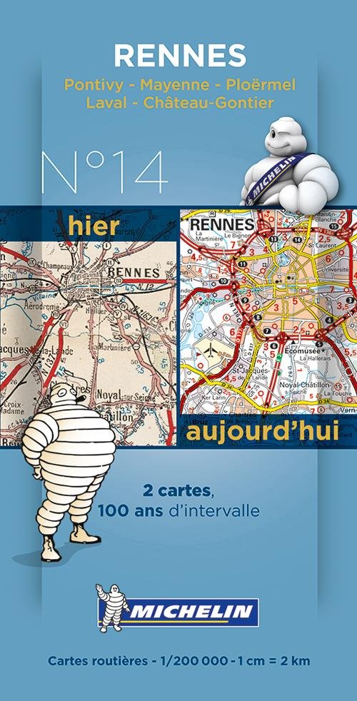
Michelin France Centenary Map 14: Rennes : Pontivy - Mayenne - Ploërmel, Laval - Château-Gontier
Michelin
Nasi klienci mówią:

Michelin France Centenary Map 14: Rennes : Pontivy - Mayenne - Ploërmel, Laval - Château-Gontier
Michelin
New and historical map of Rennes in a smart plastic sleeve.
Commemorating the 100th anniversary of the 1st World War and celebrating 100 years of its mapping scale 1/200,000, Michelin proudly introduces a new historical map collection.
The Rennes centenary map includes a facsimile of early 20th century mapping and the same map from today, both scaled 1/200,000. This pack offers a unique view of what cities such as Rennes, Ponitivy, Mayenne, Ploermel, Laval and Chateaux Gontier looked like before the war and how they look like today.
colour mapping
| Media | Książki Print (Różne materiały drukowane) |
| Wydane | 14 stycznia 2014 |
| ISBN13 | 9782067192249 |
| Wydawcy | Michelin |
| Genre | Maps & Guides |
| Wymiary | 250 g (Waga (szacunkowa)) |
| Język | French |
Więcej od Michelin


![Cover for Michelin · Michelin North America Large Format Road Atlas 2025: USA - Canada - Mexico - Atlas (Michelin) (Paperback Book) [14th edition] (2024)](https://imusic.b-cdn.net/images/item/original/048/9782067263048.jpg?michelin-2024-michelin-north-america-large-format-road-atlas-2025-usa-canada-mexico-atlas-michelin-paperback-book&class=scaled&v=1715760043)

Inni również kupili
![Cover for Simon Ankjærgaard · Augustoprøret 1943 (Bound Book) [1. wydanie] (2020)](https://imusic.b-cdn.net/images/item/original/379/9788711983379.jpg?simon-ankjaergaard-2020-augustoproeret-1943-bound-book&class=scaled&v=1599570193)

![Cover for Jakob Martin Strid · Den fantastiske bus (Bound Book) [1. wydanie] (2023)](https://imusic.b-cdn.net/images/item/original/098/9788702152098.jpg?jakob-martin-strid-2023-den-fantastiske-bus-bound-book&class=scaled&v=1696053829)
![Cover for Camilla Biesbjerg Markussen · Skærekager deluxe (Bound Book) [1. wydanie] (2021)](https://imusic.b-cdn.net/images/item/original/905/9788794086905.jpg?camilla-biesbjerg-markussen-2021-skaerekager-deluxe-bound-book&class=scaled&v=1631383695)
![Cover for Rough Guides · The Rough Guide to Sicily: Travel Guide with eBook - Rough Guides Main Series (Paperback Book) [12 Revised edition] (2023)](https://imusic.b-cdn.net/images/item/original/325/9781839058325.jpg?rough-guides-2023-the-rough-guide-to-sicily-travel-guide-with-ebook-rough-guides-main-series-paperback-book&class=scaled&v=1674716818)

Zobacz wszystko od Michelin ( np. Map , Paperback Book , Hardcover Book , Sewn Spine Book i Book )