
Powiedz znajomym o tym przedmiocie:
Nova Scotia & Prince Edwards Island, International Travel Maps 4. wydanie
ITM Publications
Zamówione z odległego magazynu
 Świąteczne prezenty można zwracać do 31 stycznia

Nasi klienci mówią:

Nova Scotia & Prince Edwards Island, International Travel Maps 4. wydanie
ITM Publications
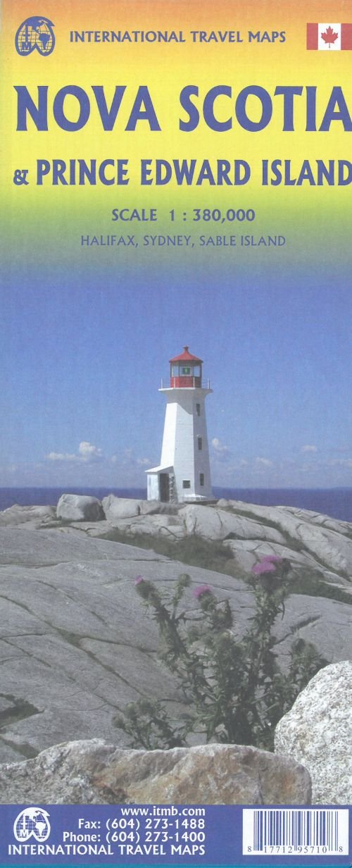
Nova Scotia is one of the most historic provinces of Canada, having become British as a result of military conquest in the 1740s. Initially, the British distrusted the Acadian settlers and moved many of them to French settlements in Louisiana, which was then a huge area of land. Some of the Acadians stayed in the South, becoming known as Cajuns; others eventually found their way back north. The fortress of Louisburg, on Cape Breton, was state of the art for its time, but was seized by the British anyway and used throughout the American revolutionary war as a bastion of British strength. The fortress has been restored and is now a national monument. Luneburg, and Halifax are both very interesting cities to visit, and Peggys Cove is probably in more peoples photo albums than any place in North America, outside of Niagara Falls. This is an excellent map as well to portray Canadas smallest province, Prince Edward Island, the home of both Canadian confederation and of the famous Anne of Green Gables, the fictional heroine of Lucy Maud Montgomerys novels. Scale 1:380.000.
Målestok: 1:380.000 Serie: International Travel Maps
| Media | Książki Hardcover Book (Książka z twardym grzbietem i okładką) |
| Wydane | 13 lutego 2020 |
| ISBN13 | 9781771295710 |
| Wydawcy | ITMB publishing |
| Genre | Maps & Guides |
| Wymiary | 500 g (Waga (szacunkowa)) |
| Język | English |
Więcej od ITM Publications


Inni również kupili

![Cover for James Joyce · Ulysses (Bound Book) [1. wydanie] [Indbundet] (2014)](https://imusic.b-cdn.net/images/item/original/584/9788763814584.jpg?james-joyce-2014-ulysses-bound-book&class=scaled&v=1412192648)
![Cover for G.W.F. Hegel · AFTRYK: Dialetik (Sewn Spine Book) [1. wydanie] (2022)](https://imusic.b-cdn.net/images/item/original/800/9788793535800.jpg?g-w-f-hegel-2022-aftryk-dialetik-sewn-spine-book&class=scaled&v=1661237403)
![Cover for Den Grønne Ungdomsbevægelse · En Grøn Retfærdig Fremtid (Sewn Spine Book) [1. wydanie] (2022)](https://imusic.b-cdn.net/images/item/original/000/9788794406000.jpg?den-groenne-ungdomsbevaegelse-2022-en-groen-retfaerdig-fremtid-sewn-spine-book&class=scaled&v=1670182722)
![Cover for Ole Grünbaum · Tusind og en nats samtaler (Sewn Spine Book) [1. wydanie] (2016)](https://imusic.b-cdn.net/images/item/original/152/9788779733152.jpg?ole-grunbaum-2016-tusind-og-en-nats-samtaler-sewn-spine-book&class=scaled&v=1463826370)
![Cover for Homer · Homers Odyssé (Paperback Book) [2. wydanie] [Paperback] (2006)](https://imusic.b-cdn.net/images/item/original/524/9788702053524.jpg?homer-2006-homers-odysse-paperback-book&class=scaled&v=1333521365)

![Cover for Karina Villumsen · Det Mælkefri Køkken: Mælkefri Chokolade (Paperback Book) [1. wydanie] (2014)](https://imusic.b-cdn.net/images/item/original/092/9788799648092.jpg?karina-villumsen-2014-det-maelkefri-koekken-maelkefri-chokolade-paperback-book&class=scaled&v=1417735841)
Zobacz wszystko od ITM Publications ( np. Hardcover Book , Print , Map , Book i Sewn Spine Book )