
Powiedz znajomym o tym przedmiocie:
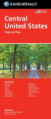
Rand McNally Folded Map: Central United States Map
Rand McNally
Nasi klienci mówią:

Rand McNally Folded Map: Central United States Map
Rand McNally
Rand McNally's folded map featuring the Central United States is a must-have for anyone traveling in and around this part of the country, offering unbeatable accuracy and reliability at a great price. Our trusted cartography shows all Interstate, state, and county highways, along with clearly indicated points of interest, airports, county boundaries, and more. You'll see why Rand McNally folded maps have been the trusted standard for years. -Regularly updated, full-color maps. -Clearly labeled Interstate, U. S., state, and county highways. -Detail maps of major cities, a mileage chart, and a Mileages & Driving Times Map. - Indications of parks, points of interest, airports, county boundaries, and more. -Easy-to-use legend. -Detailed index. Coverage Area: Arkansas, Illinois, Iowa, Kansas, Louisiana, Minnesota, Mississippi, Missouri, Nebraska, North Dakota, Oklahoma, South Dakota, Texas, and Wisconsin. Product Details: Measures 9.5 x 4.125 and folds out to 40 x 28. Scale: 1 = 43 miles.
| Media | Książki Map (Mapy lądowe lub morskie) |
| Wydane | 6 sierpnia 2021 |
| ISBN13 | 9780528024597 |
| Wydawcy | Rand McNally |
| Wymiary | 102 × 236 × 8 mm · 250 g (Waga (szacunkowa)) |
| Język | English |
Więcej od Rand McNally


![Cover for Rand McNally · A Pocket Atlas of the [world] [cartographic Material]: Presented to the Patrons and Friends of the Chicago & North-Western Ry. Co. With the Compliments of the Passenger Department (Paperback Book) (2021)](https://imusic.b-cdn.net/images/item/original/417/9781015179417.jpg?rand-mcnally-2021-a-pocket-atlas-of-the-world-cartographic-material-presented-to-the-patrons-and-friends-of-the-chicago-north-western-ry-co-with-the-compliments-of-the-passenger-department-paperback-book&class=scaled&v=1649334010)
Inni również kupili
![Cover for Preben Hansen · Turen Går Til: Turen går til Californien & Vestlige USA (Sewn Spine Book) [5. wydanie] (2021)](https://imusic.b-cdn.net/images/item/original/578/9788740063578.jpg?preben-hansen-2021-turen-gaar-til-turen-gaar-til-californien-vestlige-usa-sewn-spine-book&class=scaled&v=1623395637)
![Cover for J. K. Rowling · Harry Potter: Harry Potter 6 - Harry Potter og Halvblodsprinsen (Bound Book) [5. wydanie] (2015)](https://imusic.b-cdn.net/images/item/original/277/9788702173277.jpg?j-k-rowling-2015-harry-potter-harry-potter-6-harry-potter-og-halvblodsprinsen-bound-book&class=scaled&v=1441302687)
![Cover for Olga Ravn · De ansatte (Sewn Spine Book) [1. wydanie] (2018)](https://imusic.b-cdn.net/images/item/original/583/9788702265583.jpg?olga-ravn-2018-de-ansatte-sewn-spine-book&class=scaled&v=1521711504)
![Cover for Paludans Bilatlas over Europa 2016 (Spiral Book) [1. wydanie] (2016)](https://imusic.b-cdn.net/images/item/original/473/9788772307473.jpg?2016-paludans-bilatlas-over-europa-2016-spiral-book&class=scaled&v=1532297840)
![Cover for Betty Edwards · Drawing on the Right Side of the Brain: A Course in Enhancing Creativity and Artistic Confidence: definitive 4th edition (Hardcover Book) [Main edition] (2013)](https://imusic.b-cdn.net/images/item/original/778/9780285641778.jpg?betty-edwards-2013-drawing-on-the-right-side-of-the-brain-a-course-in-enhancing-creativity-and-artistic-confidence-definitive-4th-edition-hardcover-book&class=scaled&v=1398870041)

![Cover for Kent Haruf · Eventide - Plainsong (Paperback Book) [Main Market Ed. edition] (2013)](https://imusic.b-cdn.net/images/item/original/457/9781447240457.jpg?kent-haruf-2013-eventide-plainsong-paperback-book&class=scaled&v=1396360108)


![Cover for Barbara Kingsolver · Demon Copperhead: Winner of the Women's Prize for Fiction (Paperback Book) [Main - Re-issue edition] (2023)](https://imusic.b-cdn.net/images/item/original/483/9780571376483.jpg?barbara-kingsolver-2023-demon-copperhead-winner-of-the-women-s-prize-for-fiction-paperback-book&class=scaled&v=1680172538)
![Cover for Disney · Carl Barks & Don Rosa Bind II (Hardcover Book) [1. wydanie] (2020)](https://imusic.b-cdn.net/images/item/original/218/9788793840218.jpg?disney-2020-carl-barks-don-rosa-bind-ii-hardcover-book&class=scaled&v=1596799987)
Zobacz wszystko od Rand McNally ( np. Paperback Book , Map , Hardcover Book , Book i Spiral Book )